
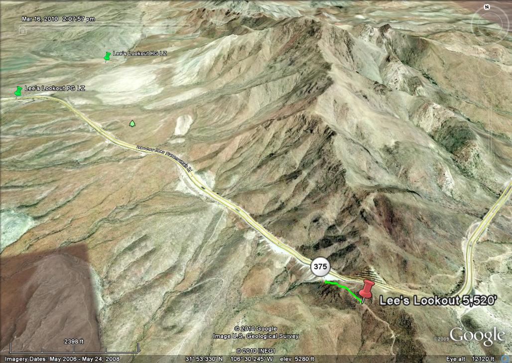
Lee's Lookout
This site is CLOSED because of dangerous hazards at launch. The site is also overgrown with weeds and bushes and a safe launch is no longer possible.
31.877933° -106.500250° 5,520 MSL 1,000' AGL
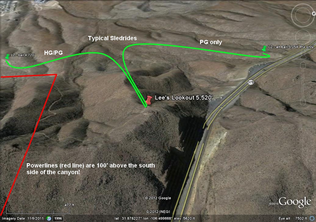
LZ 31.910659° -106.519001° and 31.876146° -106.519084°
Bail LZ's: PG/HG 31.871923° -106.507787° PG only 31.882664° -106.507055°
WARNING: Pilots must have expert launching skills to use this site! Do not attempt to fly this site if you cannot safely launch from a 45 degree sloped postage-stamp!
USHPA required notification: The RGSA and Southwest Airsports recommend that you do not fly at this site as it is not a chapter managed site. If you do choose to fly at this site, you must take full responsibility for your actions, and recognize that you are fully and solely liable for any damage incurred by yourself, to others, or to others’ property. This site is unimproved with significant safety issues, including potentially challenging wind and thermal conditions. Flying at this site can be risky to the pilot, property owners, and our sport as a whole. This site is unpermitted, uninsured, unmanaged, and unimproved.
Introduction
Lee's Lookout is one of our better west-facing sites for flying in the Franklin Mountains State Park. It is named after local pilot Lee Boone, deceased, the discoverer of the site. It is a vertical (12) minute hike from the Transmountain Pass highway (SR #375). As pilots will enter the Park, they must be registered and have paid the daily use fee (or have a Texas State Park pass). For registration and passes go to the Park registration site.
Lee's Lookout may be flown when:
1.) It is too weak to launch from Agave.
2.) Wind direction at Santa Teresa (the National Weather Service location in our region) is west to southwest (PG only).
PG pilots should not launch if winds are northwest – the site is too small to safely inflate a glider with this wind direction. If winds at the surface are west/southwest and greater than 8-10, launching from Agave is much safer. Minimum wind speed depends on the pilot's skill. 3-8 mph will work just fine as the site is thermic. If you can do the 35 minute hike to Nelson's, go there. HG pilots can launch in any direction. Lee's Lookout has the advantage of being just above the daily inversion which reaches about 5,000' MSL. It will have sufficient air to launch when Agave is calm. Its proximity to the Dragons Mouth (DM) ensures that any west component in the wind will be almost southwest at launch due to the strong venturi at DM which makes launch easier when conditions are weak everywhere else. Launch is tight (10 yd. x 10 yd.). If PG pilots walk down the steep slope a ways and lay their wing out near the edge, inflation is easier. The downside is that the pilot cannot see his lines until the glider comes up – someone helping can help scan them. HG should not have any problems as the launch to north/right has a sheer cliff in front.
PG pilots should always launch to the left (facing almost south) and follow the ridge out. The stronger the conditions, the more the pilot will ascend immediately after launch. In weaker conditions, he may have to follow the ridge out and hunt for thermals – there are always plenty of them. Remember that the geography of Lee's Lookout ensures that winds at launch will be from the south (strong conditions) or southwest (weaker conditions) because of the venturi at DM. That is, if winds at Santa Teresa are west, the winds at launch will be southwest or south.
The northwest portion of the site can be very thermic due to its dark color and west face, even at the end of the day. But as the pilot is launching to the south (and left), it is safe to launch during a lull as the thermals moving up the northwest part of the site will not affect the air out in front to the left. When winds are west to southwest miles out front, the venturi of the DM causes the air to swirl around the ridge and up the northwest part of the launch area triggering thermals in the process. Accordingly, the air to the south or left will be smooth all the way out if, for example, it is late in the day. Otherwise, thermal strength out front will be the same as elsewhere in the range. The weaker the conditions, the less pronounced this effect is. This has been proven many times by actual flights from the site.
LZ
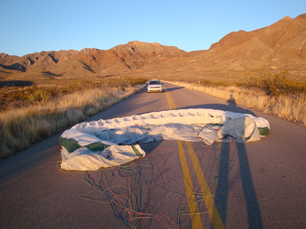
The main LZ is the area around the Tom Mays Park entrance 2.6 miles NW of launch. Park a vehicle just outside the entrance gate of Tom Mays Park and drive another to the top of the Pass. It is somewhat easier for PG pilots to land on the Tom Mays access road east of the gate as they can set up a mile away. As there are often thermals popping off everywhere around the roads, using the access road east of the gate allows for plenty of margin. The access road slopes down for a half a mile and is clear on both sides. HG pilots should land at the normal LZ for Agave Hill which is 6/10ths of a mile NE of the PG LZ. If there are cars on the road, just land in the bushes on the south side of the road. You may have to spend some time picking your lines out of them but consider what an amazing flight you just had.
Landing in the desert is often more complicated than coastal or other inland sites because of the very hot ground at the surface (+140°F in the summer) which causes small but powerful thermals to pop off near the surface. They can dramatically change where you land.
The PG LZ near the entrance of Tom Mays Park. The access road faces SW and is a 1/2-mile-long so pilots can relax and setup without worry if they encounter thermals while landing. The vehicle in the photo stopped and waited for the pilot to get out of the way.
Bail LZ Info
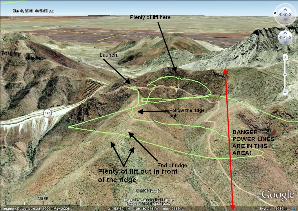
If you do a sled ride from launch, just follow the ridge straight out and then make a 90° turn either direction at the end (left for HG/PG or right for PG only). If you go left (south), head for the dirt road that goes from the top of the ridge down the canyon to a housing development. It is plenty long and slopes down at first and then becomes almost level near the housing development. If you go left, remember that it is at least (40) minute drive one way from the pass to pick you up so you must have a driver. To get to the HG/PG bail LZ from the Transmountain highway, go west down the hill for about (5) miles and turn left (south) on N. Resler. j Go 3.4 miles, turn left (east) on High Ridge drive and then go 1.9 miles to the end (at the time of this writing, there is some unimproved road at the end). Make a quick jag right and then left onto Calle Lago for 0.4 miles where there is a gate (it's a gated community). If it's open, you're in luck. If not, you will have to walk up and find your pilot somewhere.
If conditions at the DM are not too strong, PG pilots can fly out to the end of the ridge at launch, turn right (north), and cautiously go in front of the DM at low altitude (<5,000' MSL). Stay well in front of the DM and land on the top of the second finger ridge (past the most northwest of the picnic areas). It is an easy hike from the PG bail LZ to the highway and then to the top of the Pass. The second finger ridge has a road going down it so it is easy to spot. This LZ is nice if the air is dead as it goes downhill the whole way.
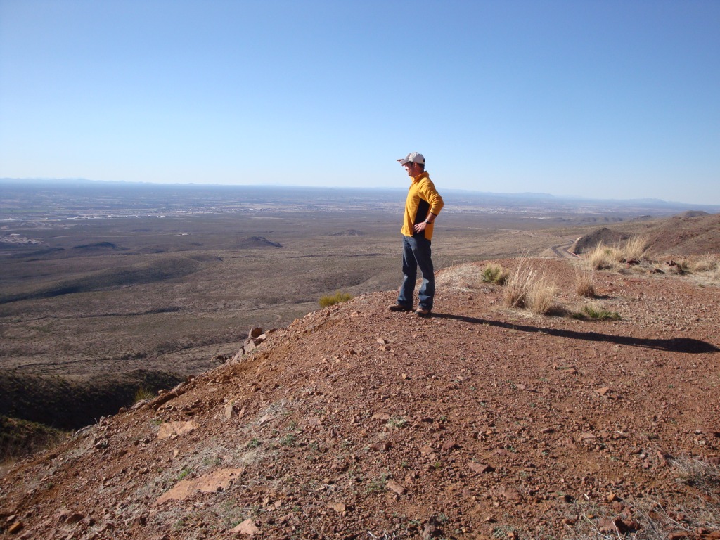
The view here is to the west.
Below – view looking northwest. The late Lee Boone is the discoverer of this excellent site.
Site hazards and risk management
Launching from this site has two dangers. Be extremely careful of getting sucked into the DM. It is unlikely to happen if you check the wind velocity at the Pass before you hike up. If it's blowing more than 18 at the Pass, be extremely careful when launching – go straight out and keep left of the ridge in front. Better yet, pack up and launch from Agave. If the air at the Pass is less than 18, you are safe no matter where you fly but note that lift disappears at the DM. Landing on the highway is not only illegal but dangerous.
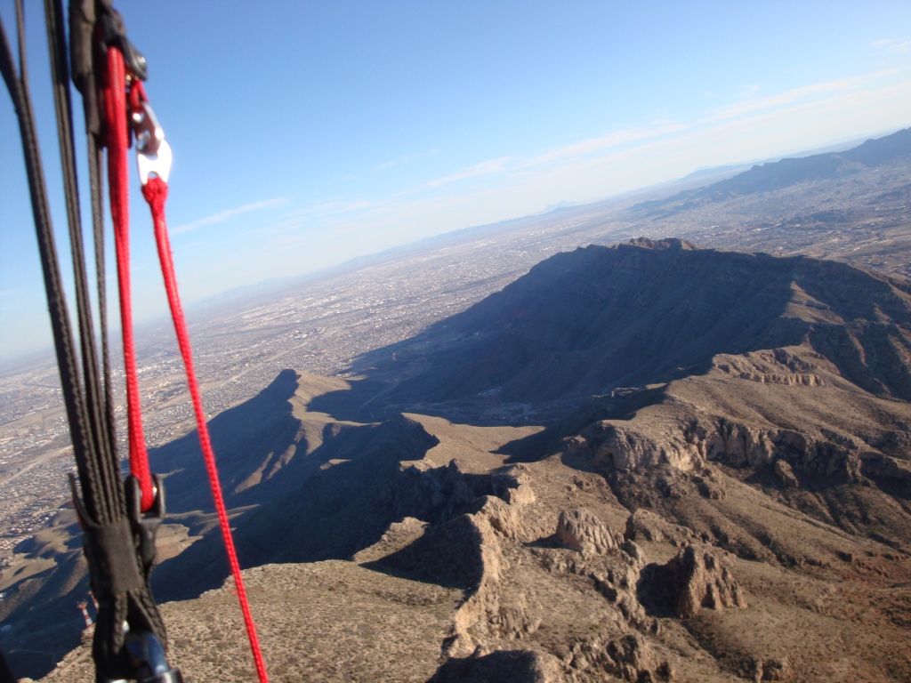
The second danger is the presence of power lines that go east – west along the side of the canyon to the south of launch. They are almost invisible. Make sure that you get a few hundred over launch before you head south and up. In general – STAY AWAY FROM THE SOUTH SIDE OF THE CANYON NEXT TO LAUNCH UNLESS YOU ARE HIGHER THAN THE RIDGE BEHIND. The power lines, fortunately, turn south after leaving the canyon and the poles are easily visible. Below is an image of a recent flight from Lee's Lookout. The pilot was higher than the ridge behind launch when he flew south. View is looking east.
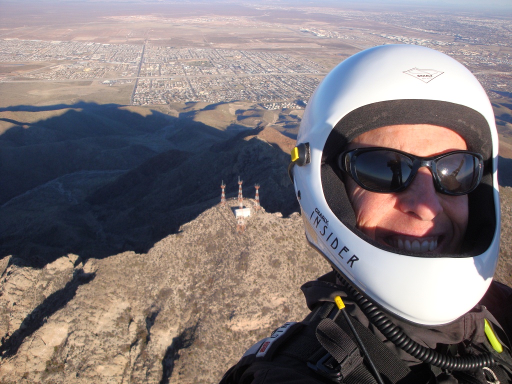
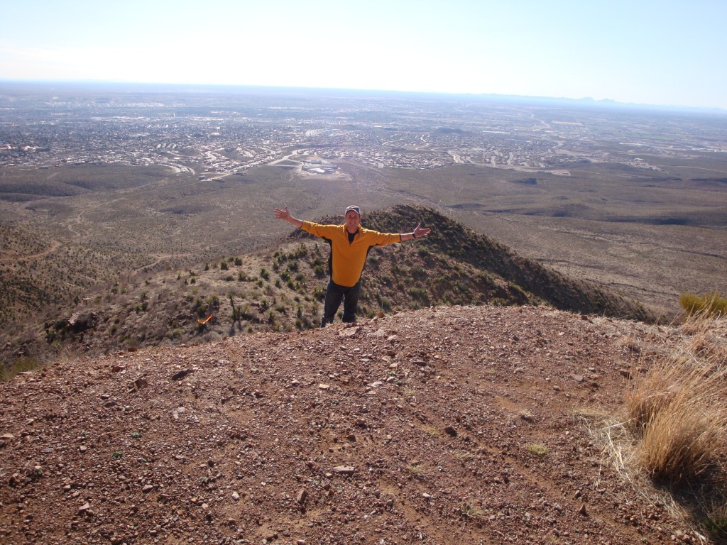
View of South Mt. Franklin (Radio Peak) after a successful trip up from Lee's Lookout. You want to smile, too? Fly year 'round in the Franklins with us! From here, this pilot went over 1,000' above the top of the range.
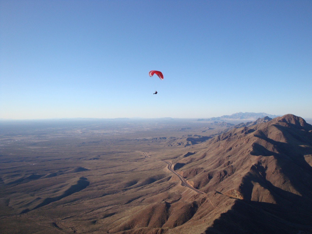
View 1/2 mile above and just south of launch. From here a pilot can fly all the way to the end of the range. HG pilot Dick Moody once flew from here to Ascarate Park many years ago.
The site's rating (H/P3) is due to the following: 1.) It is a very tight launch area – less than 10 yd. on each side. 2.) There is a shear cliff just north of launch (good for HG). 3.) You can be blown over the back or sucked into the Dragon's Mouth. 4.) There are numerous desert plants in the vicinity of the launch area that can snag the pilot/glider. (It is a safer HG launch than PG.) Despite these hazards, the site is the best we have for advanced pilots flying in the Franklins. Those who successfully launch are virtually guaranteed to get up and out. The bailout LZ is easily reachable and safe for both HG and PG. Pilots should not fly this site alone because a minor problem at launch could easily cascade. A helper can assist with layout, the inflation of the glider, look for any potential problems, and help the pilot in the event of a failed launch.
The late Lee Boone (photo below) is standing about where a PG pilot should launch from. When launching, follow the top of the ridge out. At the end there is plenty of lift with thermals galore popping off the power lines at the base of the mountain. (The poles can just be seen near the dirt road.) If you launch at the right time of the cycle, you will get in strong lift right at launch and go straight up. You should always turn left, bench up the ridge behind launch, and get high enough to safely pass over the power lines. Follow the ridge south until you get to S. Mt. Franklin and work your way up via thermals and ridge lift. It's an easy task for most pilots. Then you are in the magic airspace above the range and can fly for hours in any direction. Here is info on safely flying in the Franklins once you are above launch.
Below is a view looking out from launch to the SW.
The late Lee Boone parked in front of the Franklins above Lee's Lookout at 7,500'. Lift is everywhere....
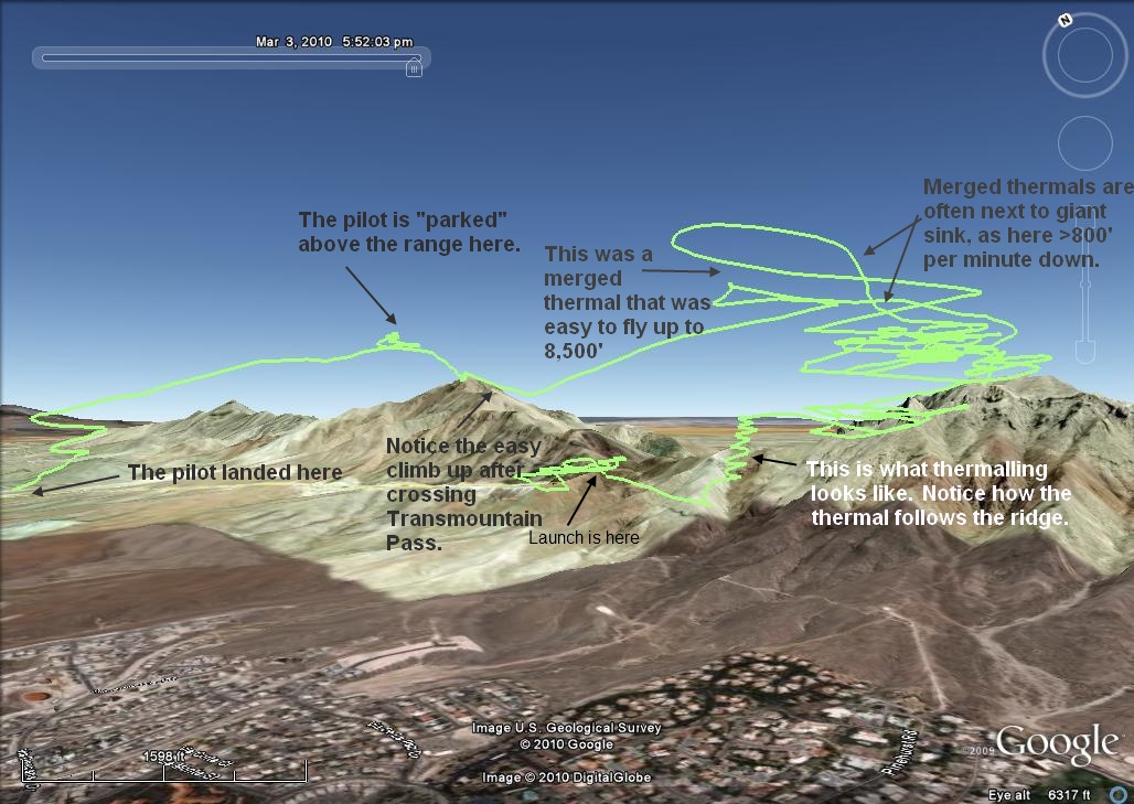
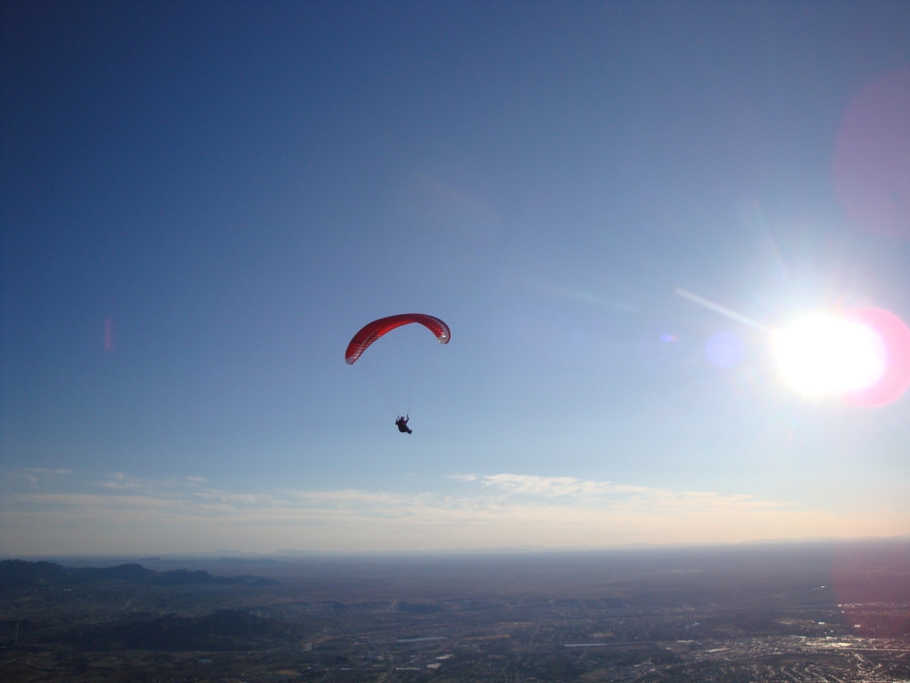
Below is an image of a typical flight from Lee's Lookout. Most P/H3 pilots should be able to do this without any trouble.
Pilot Registration
You must register with the Park before entering or flying. Solo pilots (not recommended) need to notify the Park Police or a Park Ranger before launching.
Below, the late Lee Boone soars above the range in the amazing lift that is above the Franklins. Lift is everywhere once you pass 7,000'. This was his first flight from Lee's Lookout and he had no trouble benching up. Pilots can soar the front of these mountains for over 25 miles.
![]()