La Luz launch – Alamogordo, NM
NOTE: SOME OF THE INFORMATION HERE MAY NOT BE CURRENT. PLEASE GO TO THE RIO GRANDE SOARING ASSOCIATION SITE GUIDE FOR THE MOST CURRENT INFORMATION.
La Luz, NM 32.971658° -105.917189° 5,856' MSL 1,100' AGL
USHPA required notification: The RGSA and Southwest Airsports recommend that you do not fly at this site as it is not a chapter managed site. If you do choose to fly at this site, you must take full responsibility for your actions, and recognize that you are fully and solely liable for any damage incurred by yourself, to others, or to others’ property. This site is unimproved with significant safety issues, including potentially challenging wind and thermal conditions. Flying at this site can be risky to the pilot, property owners, and our sport as a whole. This site is unpermitted, uninsured, unmanaged, and unimproved.
There are (3) launch areas that favor a particular wind direction. Choose the one that has the air coming in the straightest. PG pilots should be aware that the launch areas were pioneered by HG pilots and are not necessarily that good for PG per having a clean layout area, lack of rotor behind launch near the ground, and a long run area. We do not recommend this site for paragliding because of the tricky winds at launch and strong thermals coming off the city water works holding tanks below launch.
If Dry Canyon is not flyable then we recommend that pilots stay on the ground. Numerous pilots have been injured or frightened at La Luz. We do not recommend La Luz as a flying site under any conditions.
Flyable with southwesterly to northerly winds. It is primarily used when Dry Canyon will not work (when winds are northwest or north). It is safer than Dry Canyon for newer pilots as the LZ is an easy glide from launch.
The primary LZ is an enormous field about an 8:1 glide off to the west. A sled run is typically 5 minutes in duration, but soaring flights do occur. Directions to the LZ: From Hwy 70/54 go on Hwy 82 east towards Cloudcroft. Take a left at the blinking lights that mark Florida Avenue, and go north about a mile or so to Valley View Drive, about 100 yards before you reach the trees of the village. Go right about ¼ mile to where you can look over the barbed wire into the huge open field. Don’t drive into the field, though – it’s private property. Hazards: There is a power line running from northeast to southwest across the east edge of the field.
View from the NW launch. This launch is flat and would be rated "C" for PG launching in light winds as the run is short and slightly shadowed by the cliff face.
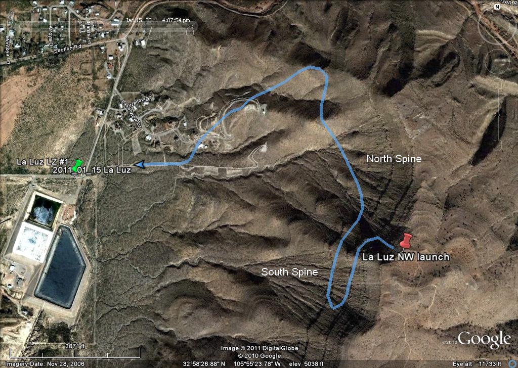
Per the image below, when winds are northwest or west, the area of max lift was not the north spine but was the south spine. The sink over the canyon between the two spines was severe – as we would expect. Elevation profiles of the PG track below clearly showed the lift patterns of the spines – the south was much more robust.
![]()
